|
Picture of the day -
October 3, 2006
North America At Night
Click photo to enlarge.
Photo courtesy of
NASA.
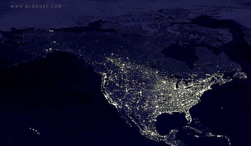
Today's picture features a very interesting "nighttime view" of
the North American continent. It is a portion of an
image produced by NASA that shows all of the
earth's land masses
at once.
The bright areas are cities and towns with their numerous man-made
lights shining out into space. As you an easily tell, the eastern
half of the United States is the most heavily populated segment of
the continent along with the Atlantic, Pacific and Gulf coasts.
When Europeans began to "settle" the New World, they knew that the
fastest and easiest way to transport goods and people to other parts
of the world was by boat and ship, so they built their cities and
towns along the seacoasts, the Great Lakes and the continent's major
rivers. That's why there are many "strings" of light scattered
throughout the image.
Even though Canada has the largest land mass in North America (and
the second largest in the entire world), it is so sparsely populated
that the much-smaller Mexico has roughly 3 times as many people -
and a quick glance at the distribution of light shows it. Canada has
about 1/10 as many people as the United States, and the vast
majority of them live within a couple of hundred miles of the
American border. In fact, southern Canada and the northern US are
really just one large population center sitting to the south of a
massive, largely un-populated expanse of wilderness.
Another interesting thing about the picture is the short line of
"dots" way out in the Pacific Ocean due west of Mexico. These are
the Hawaiian islands, the most remote area in the greater United
States. I always knew that Hawaii was quite far from the rest of the
country, but this photo sure puts that great distance into
perspective!
NASA produces some absolutely incredible images, and in my opinion
their
composite view of the earth at night is one of the most
spectacular of the entire lot!
Picture Of The Day Homepage |
Submit
a photo
More Interesting Articles
|
|
|