|
Picture of the day - July 13, 2005
Hurricane Dennis
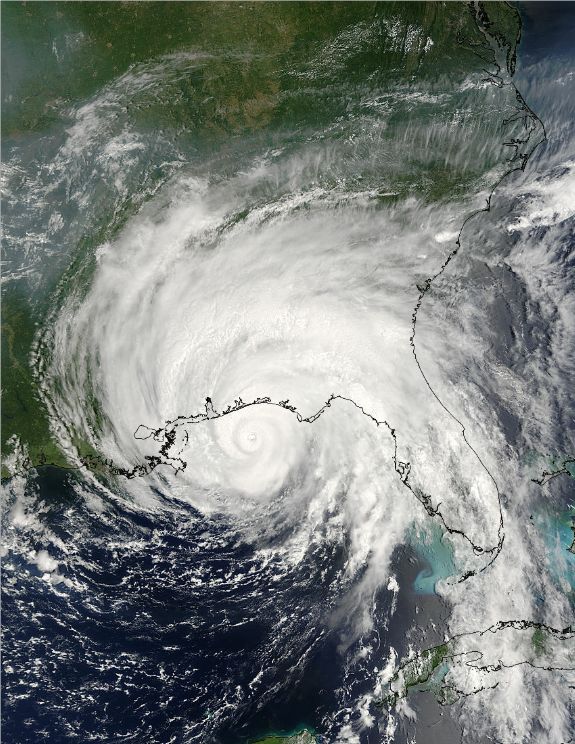
Photo courtesy of NASA.
In the realm of weather phenomena, the hurricane has no equal when
it comes to inspiring awe and fear in the minds of us humans. These gigantic
storms can span a thousand miles or more with winds well over 100mph. The
destruction left behind after a hurricane has passed over a land mass can
destroy lives and empty national treasuries in just a few hours.
But the detrimental effects of hurricanes aside, when viewed from space they are
among nature's most beautiful creations. The buffeting winds and clouds spinning
around a tightly defined "eye" appear to be moving in slow motion from
many miles above the earth, masking the devastation that is often taking place
below them. A perfect example is the subject of today's picture, Hurricane
Dennis, just before it made landfall on the Gulf coast of the United States
on July 10.
Hurricanes are rotating areas of intense low air pressure that form over warm
waters (at least 80 degrees Fahrenheit). The rotation of the earth is the
catalyst that causes the low pressure area to start spinning (a phenomenon
called the Coriolis effect). The resulting disturbance is called a tropical
storm until the winds reach 74 miles per hour, at which point it becomes a
hurricane.
All low-pressure systems, including tropical storms and hurricanes, spin counter-clockwise in the northern hemisphere and clockwise in the southern
hemisphere due to the nature of the Coriolis effect. Low pressure systems cannot
start spinning within 2 degrees of the equator because the Coriolis force is too
weak to set the air mass into motion.
In North America, we call these awesome storms hurricanes. In the western north
pacific region they are called typhoons, and they are referred to as tropical
cyclones in the Indian ocean and the western South Pacific.
Picture Of The Day Homepage | Submit
a photo
Interesting Articles
|
|